Meteorological dangerous phenomena– natural processes and phenomena that occur in the atmosphere under the influence of various natural factors or their combinations, which have or may have a damaging effect on people, farm animals and plants, economic objects and the natural environment.
Wind - this is the movement of air in parallel earth's surface, arising as a result of uneven distribution of heat and atmospheric pressure and directed from the zone high pressure in a low pressure zone.
Wind is characterized by:
1. Wind direction - determined by the azimuth of the side of the horizon from where
it blows, and is measured in degrees.
2. Wind speed - measured in meters per second (m/s; km/h; miles/hour)
(1 mile = 1609 km; 1 nautical mile = 1853 km).
3. Wind force - measured by the pressure it exerts on 1 m2 of surface. The strength of the wind varies almost proportionally to the speed,
therefore, wind force is often measured not by pressure, but by speed, which simplifies the perception and understanding of these quantities.
Many words are used to denote the movement of wind: tornado, storm, hurricane, gale, typhoon, cyclone and many local names. To systematize them, people all over the world use Beaufort scale, which allows you to very accurately estimate the strength of the wind in points (from 0 to 12) by its effect on ground objects or on waves at sea. This scale is also convenient because it allows you to quite accurately determine the wind speed without instruments based on the characteristics described in it.
Beaufort scale (Table 1)
Points |
Verbal definition |
Wind speed, |
Wind action on land |
|
On land |
At sea |
|||
0,0 – 0,2 |
Calm. Smoke rises vertically |
Mirror smooth sea |
||
Quiet breeze |
0,3 –1,5 |
The direction of the wind is noticeable by the direction of the smoke, |
Ripples, no foam on the ridges |
|
Light breeze |
1,6 – 3,3 |
The movement of the wind is felt by the face, the leaves rustle, the weather vane moves |
Short waves, crests do not capsize and appear glassy |
|
Light breeze |
3,4 – 5,4 |
Leaves and thin branches of trees sway, the wind flutters the upper flags |
Short, well-defined waves. The ridges, overturning, form foam, and occasionally small white lambs are formed. |
|
Moderate breeze |
5,5 –7,9 |
The wind raises dust and pieces of paper and moves thin tree branches. |
The waves are elongated, white caps are visible in many places. |
|
Fresh breeze |
8,0 –10,7 |
Thin tree trunks sway, waves with crests appear on the water |
The waves are well developed in length, but not very large; whitecaps are visible everywhere. |
|
Strong breeze |
10,8 – 13,8 |
Thick tree branches sway, wires hum |
Large waves begin to form. White foamy ridges occupy large areas. |
|
strong wind |
13,9 – 17,1 |
The tree trunks are swaying, it’s difficult to walk against the wind |
The waves pile up, the crests break off, the foam lies in stripes in the wind |
|
Very strong wind storm) |
17,2 – 20,7 |
The wind breaks tree branches, it is very difficult to walk against the wind |
Moderately high, long waves. Spray begins to fly up along the edges of the ridges. Stripes of foam lie in rows downwind. |
|
Storm |
20,8 –24,4 |
Minor damage; the wind tears off smoke hoods and tiles |
High waves. The foam falls in wide dense stripes in the wind. The crests of the waves capsize and crumble into spray. |
|
Severe storm |
24,5 –28,4 |
Significant destruction of buildings, trees are uprooted. Rarely happens on land |
Very high waves with long curls |
|
Fierce Storm |
28,5 – 32,6 |
Large destruction over a large area. Very rarely observed on land |
Exceptionally high waves. Vessels are hidden from view at times. The sea is all covered with long flakes of foam. The edges of the waves are blown into foam everywhere. Visibility is poor. |
|
32.7 or more |
Heavy objects are carried by wind over considerable distances |
The air is filled with foam and spray. The sea is all covered with stripes of foam. Very poor visibility. |
||
Breeze (light to strong breeze) sailors call winds that have a speed of 4 to 31 mph. In terms of kilometers (coefficient 1.6) it will be 6.4-50 km/h
Wind speed and direction determine weather and climate.
Strong winds, significant changes in atmospheric pressure and large amounts of precipitation cause dangerous atmospheric vortices (cyclones, storms, squalls, hurricanes) that can cause destruction and loss of life.
Cyclone – common name vortices with low blood pressure in the center.
An anticyclone is an area of high pressure in the atmosphere with a maximum in the center. In the Northern Hemisphere, the winds in an anticyclone blow counterclockwise, and in the Southern Hemisphere they blow clockwise; in a cyclone the wind movement is reversed.
Hurricane
- wind of destructive force and significant duration, the speed of which is equal to or exceeds 32.7 m/s (12 points on the Beaufort scale), which is equivalent to 117 km/h (Table 1).
In half of the cases, the wind speed during a hurricane exceeds 35 m/sec, reaching 40-60 m/sec, and sometimes up to 100 m/sec.
Hurricanes are classified into three types based on wind speed:
- hurricane
(32 m/s or more),
- strong hurricane
(39.2 m/s or more)
- violent hurricane
(48.6 m/s or more).
The reason for such hurricane winds is the emergence, as a rule, on the line of collision of fronts of warm and cold air masses, powerful cyclones with a sharp pressure drop from the periphery to the center and with the creation of a vortex air flow moving in the lower layers (3-5 km) in a spiral to the middle and upwards, in the northern hemisphere - counterclockwise.
Such cyclones, depending on the place of their origin and structure, are usually divided into:
-
tropical cyclones found over warm tropical oceans, during the formation stage they usually move to the west, and after formation ends they bend towards the poles.
A tropical cyclone that has reached unusual strength is called hurricane,
if it is born in the Atlantic Ocean and its adjacent seas; typhoon -
in the Pacific Ocean or its seas; cyclone –
in the Indian Ocean region.
mid-latitude cyclones can form both over land and over water. They usually move from west to east. Characteristic feature Such cyclones are characterized by their great “dryness”. The amount of precipitation during their passage is significantly less than in the zone of tropical cyclones.
The European continent is affected by both tropical hurricanes originating in the central Atlantic and cyclones of temperate latitudes.
Storm
–
a type of hurricane, but has a lower wind speed of 15-31
m/sec.
The duration of storms is from several hours to several days, the width is from tens to several hundred kilometers.
Storms are divided:
2. Stream storms
–
These are local phenomena of small distribution. They are weaker than vortex storms. They are divided:
- stock – the air flow moves down the slope from top to bottom.
- Jet – characterized by the fact that the air flow moves horizontally or up a slope.
Stream storms most often occur between chains of mountains connecting valleys.
Depending on the color of the particles involved in the movement, black, red, yellow-red and white storms are distinguished.
Depending on the wind speed, storms are classified:
- storm 20 m/sec or more
- strong storm 26 m/sec or more
- severe storm of 30.5 m/sec or more.
Squall – a sharp short-term increase in wind up to 20–30 m/s and higher, accompanied by a change in its direction associated with convective processes. Despite the short duration of squalls, they can lead to catastrophic consequences. Squalls are most often associated with cumulonimbus (thunderstorm) clouds of either local convection or a cold front. A squall is usually associated with showers and thunderstorms, sometimes with hail. During a squall, atmospheric pressure rises sharply due to rapid precipitation, and then falls again.
If it is possible to limit the impact zone, all of the listed natural disasters are classified as non-localized.
Dangerous consequences of hurricanes and storms.
Hurricanes are one of the most powerful forces elements and in their harmful effects are not inferior to such terrible natural disasters as earthquakes. This is explained by the fact that hurricanes carry enormous energy. Its amount released by an average hurricane during 1 hour is equal to the energy nuclear explosion at 36 Mt. In one day, an amount of energy is released that would be enough to supply a country like the United States with electricity for six months. And in two weeks (the average duration of a hurricane’s existence), such a hurricane releases energy equal to the energy of the Bratsk hydroelectric power station, which it can produce in 26 thousand years. The pressure in the hurricane zone is also very high. It reaches several hundred kilograms per square meter a fixed surface located perpendicular to the direction of wind movement.
Hurricane wind destroys strong and demolishes light buildings, devastates sown fields, breaks wires and knocks down power and communication line poles, damages highways and bridges, breaks and uproots trees, damages and sinks ships, causes accidents in public utility networks and in production. There are known cases when hurricane winds destroyed dams and dams, which led to large floods, threw trains off the rails, tore bridges from their supports, knocked down factory chimneys, and threw ships onto land. Hurricanes are often accompanied by heavy downpours, which are more dangerous than the hurricane itself, as they cause mudflows and landslides.
Hurricane sizes vary. Usually, the width of the catastrophic destruction zone is taken as the width of a hurricane. Often this zone is supplemented with an area of storm force winds with relatively little damage. Then the width of the hurricane is measured in hundreds of kilometers, sometimes reaching 1000 km. For typhoons, the destruction strip is usually 15-45 km. The average duration of a hurricane is 9-12 days. Hurricanes occur at any time of the year, but are most common from July to October. In the remaining 8 months they are rare, their paths are short.
The damage caused by a hurricane is determined by a whole complex of various factors, including the terrain, the degree of development and strength of buildings, the nature of vegetation, the presence of people and animals in its area of effect, the time of year, preventive measures taken and a number of other circumstances, the main of which is speed pressure of air flow q, proportional to the product of atmospheric air density by the square of air flow speed q = 0.5pv 2.
According to building codes and regulations, the maximum standard value of wind pressure is q = 0.85 kPa, which, with an air density of r = 1.22 kg/m3, corresponds to wind speed.
For comparison, you can give the calculated values of the velocity head used for the design nuclear power plants for the Caribbean region: for buildings of category I - 3.44 kPa, II and III - 1.75 kPa and for open installations - 1.15 kPa.
Every year, about a hundred powerful hurricanes sweep across the globe, causing destruction and often claiming human lives (Table 2). On June 23, 1997, a hurricane swept over most of the Brest and Minsk regions, as a result of which 4 people were killed and 50 were injured. In the Brest region there were 229 blackouts settlements, 1071 substations were disabled, roofs were torn off from 10-80% of residential buildings in more than 100 settlements, and up to 60% of agricultural buildings were destroyed. In the Minsk region, 1,410 settlements were cut off and hundreds of houses were damaged. Trees in forests and forest parks were broken and uprooted. At the end of December 1999, Belarus also suffered from hurricane winds that swept across Europe. Power lines were broken, and many settlements were without power. In total, 70 districts and more than 1,500 settlements were affected by the hurricane. In the Grodno region alone, 325 transformer substations were out of order, in the Mogilev region even more - 665.
Table 2
Effects of some hurricanes
Location of the disaster, year |
Death toll |
Number of wounded |
Related phenomena |
Haiti, 1963 |
Not recorded |
||
Not recorded |
|||
Honduras, 1974 |
Not recorded |
||
Australia, 1974 |
|||
Sri Lanka, 1978 |
Not recorded |
||
Dominican Republic, 1979 |
|||
Not recorded |
|||
Indochina, 1981 |
Not recorded |
Flood |
|
Bangladesh, 1985 |
Not recorded |
Flood |
Tornado (tornado)- a vortex movement of air, spreading in the form of a giant black column with a diameter of up to hundreds of meters, inside of which there is a rarefaction of air, into which various objects are drawn.
Tornadoes occur both over the water surface and over land, much more often than hurricanes. Very often they are accompanied by thunderstorms, hail and downpours. The speed of air rotation in the dust column reaches 50-300 m/sec or more. During its existence, it can travel up to 600 km - along a strip of terrain several hundred meters wide, and sometimes up to several kilometers, where destruction occurs. The air in the column rises in a spiral and draws in dust, water, objects, and people.
Hazardous factors: buildings caught in a tornado due to vacuum in the air column are destroyed by air pressure from the inside. It uproots trees, overturns cars, trains, lifts houses into the air, etc.
Tornadoes occurred in the Republic of Belarus in 1859, 1927 and 1956.
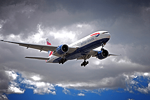
Many people wonder: at what wind speed can planes not fly? Indeed, there are certain speed limits. Compared to the speed of an aircraft, which reaches 250 m/s, even strong wind at a speed of 20 m/s will not interfere with the aircraft during flight. However, crosswinds can interfere with an airliner when it is moving at a slower speed, namely during takeoff or landing. Therefore, planes do not take off under such conditions. Air flows affect the speed of the aircraft, the direction of movement, as well as the length of the run and takeoff run. In the atmosphere, these flows are present at all altitudes. This movement of air relative to a flying airliner is translational movement. If there is a strong wind, the direction of movement of the airliner in relation to the ground does not coincide with the longitudinal axis of the aircraft. Strong air currents can blow the plane off course.
Airliners always land and take off against the direction of the wind. In the case of takeoff or landing with a tailwind, the length of the takeoff and run increases significantly. When taking off or landing, an airliner penetrates the lower layer of the atmosphere so quickly that the pilot does not have time to react to changes in the wind. If he does not know about a sharp increase or, conversely, weakening of air flows in the lower layers of the atmosphere, this is fraught with a plane crash.
During takeoff, as the airliner gains altitude, it encounters a strong headwind. As the aircraft gains altitude, the lifting force of the aircraft increases. Moreover, the increase occurs faster than the pilot can control. In this case, the flight trajectory may be higher than the calculated one. If there is a sudden increase in wind, this may cause the airliner to reach a supercritical angle of attack. This can lead to disruption of the air flow and collision with the ground.
As a rule, the permissible maximum wind force determined for each aircraft individually depending on the specifics of its specific characteristics and technical capabilities. Sets the maximum wind speed at which takeoff or landing can be carried out by the airliner manufacturer. More precisely, the manufacturer sets two maximum speeds: downwind and sideways. The downwind speed for most modern airliners is the same. During takeoff and landing, the associated speed should not exceed 5 m/s. As for lateral speed, it is different for each airliner:
- for TU-154 aircraft – 17 m/s;
- for AN-24 – 12 m/s;
- for TU-134 – 20 m/s.
On average, airliners have a maximum lateral speed 17 m/s. At higher speeds, the vast majority of aircraft do not take off. If there is a sharp increase in wind in the arrival area, the speed of which exceeds the permissible levels, the planes do not land at this airport, but make an emergency landing on another runway, where conditions allow the airliner to land safely.
Answering the question of what kind of wind airplanes cannot fly in, we can say with confidence that at a speed of more than 20 m/s, if the wind blows perpendicular to the runway, takeoff cannot be carried out. Such strong winds are associated with the passage of powerful cyclones. Below you can watch a video of a plane landing in a strong crosswind to see how difficult it is even for a professional, experienced pilot with extensive experience. A particular danger in this case is gusty winds in the lower layers of the atmosphere. It can start blowing at the most inopportune moment, forming a large roll, which poses a huge danger to the aircraft.

Crosswind is dangerous because it requires the pilot to take certain actions that are very difficult to perform. In aviation there is such a thing as “drift angle”. This term refers to the amount of angle by which an airliner deviates from its intended direction due to wind. The stronger the wind, the larger this angle. Accordingly, the more effort the pilot needs to put in to turn the airliner to this angle in reverse side. As long as the aircraft is in flight, even such strong winds do not cause any problems. But as soon as the plane touches the runway surface, the airliner gains traction and begins to move in a direction parallel to its axis. At this moment, the pilot must suddenly change the direction of the airliner, which is very difficult.
As for the problem of a strong tailwind, it is easily solved by changing the operating threshold of the runway. However, not every airport has this opportunity. For example, Sochi and Gelendzhik are deprived of such an opportunity. If a strong wind blows towards the sea, landing can be carried out, but take-off under such conditions is unsafe. That is, landing an airplane in strong winds is possible, but not in all cases.
Runway condition
Even if the wind speed allows you to take off or land, there are a number of other factors that can influence the final decision. In particular, in addition to weather conditions and visibility, the condition of the runway is taken into account. If it is covered with ice, landing or takeoff cannot be carried out. In aviation there is a term called “friction coefficient”. If this indicator is below 0.3, the runway is not suitable for landing or takeoff and needs to be cleared. If the decrease in friction coefficient occurs due to heavy snowfall, during which clearing is impossible, the entire airport is closed until the weather improves. Such a break in work can last several hours.

How do you make the decision to take off?
This decision must be made by the aircraft commander. To do this, first of all, he must familiarize himself with meteorological data on departure, landing and alternate airports. For this purpose, METAR and TAF forecasts are used. The first forecast is issued for all airports every half hour. The second is provided every 3-6 hours. Such forecasts reflect all relevant information that may influence the decision to take off or cancel a flight. In particular, such forecasts contain data on wind speed and its changes.
To make a decision, all flights are conditionally divided into 2-hour and longer. If the flight lasts less than two hours, it is enough for the actual weather to be acceptable (above the established minimum) for takeoff. If the flight is longer, the TAF forecast must be additionally taken into account. If weather conditions at the destination do not allow landing, in some cases, the decision to take off may be positive. For example, if the weather conditions at your destination are below minimum, however, there are two airfields in close proximity with optimal weather conditions. But even in these cases, a positive decision is almost never made, given the danger of such a flight.
Wind- this is horizontal movement (air flow parallel to the earth's surface), resulting from uneven distribution of heat and atmospheric pressure and directed from a high pressure zone to a low pressure zone
Wind is characterized by speed (strength) and direction. Direction is determined by the sides of the horizon from which it blows, and is measured in degrees. Wind speed measured in meters per second and kilometers per hour. Wind strength is measured in points.
Wind in boots, m/s, km/h
Beaufort scale- a conventional scale for visual assessment and recording of wind force (speed) in points. Initially, it was developed by the English admiral Francis Beaufort in 1806 to determine the strength of the wind by the nature of its manifestation at sea. Since 1874, this classification has been adopted for widespread (on land and at sea) use in international synoptic practice. In subsequent years it changed and was refined (Table 2). A state of complete calm at sea was taken as zero points. Initially, the system was thirteen-point (0-12 bft, on the Beaufort scale). In 1946 the scale was increased to seventeen (0-17). The strength of the wind on the scale is determined by the interaction of the wind with various objects. IN recent years, wind strength is more often assessed by speed, measured in meters per second - at the earth's surface, at a height of about 10 m above an open, flat surface.
The table shows the Beaufort scale, adopted in 1963 by the World Meteorological Organization. The sea wave scale is nine-point (parameters are given for a large sea area; in small water areas the waves are less). Descriptions of the effects of the movement of air masses are given “for the conditions of the earth’s atmosphere near the earth’s or water surface,” and above-zero temperatures. On the planet Mars, for example, the ratios will be different.
Wind strength in Beaufort scale and sea waves
table 1
| Points | Verbal indication of wind force | Wind speed, m/s | Wind speed km/h | Wind action |
|
on land |
at sea (points, waves, characteristics, height and wavelength) |
||||
| 0 | Calm | 0-0,2 | Less than 1 | Complete absence of wind. The smoke rises vertically, the leaves of the trees are motionless. | 0. No excitement
Mirror smooth sea |
| 1 | Quiet | 0,3-1,5 | 2-5 | The smoke deviates slightly from the vertical direction, the leaves of the trees are motionless | 1. Weak excitement.
There are light ripples on the sea, no foam on the ridges. Wave height is 0.1 m, length - 0.3 m. |
| 2 | Easy | 1,6-3,3 | 6-11 | You can feel the wind on your face, the leaves rustle faintly at times, the weather vane begins to move, | 2. Low excitement
The ridges do not tip over and appear glassy. At sea, short waves are 0.3 m high and 1-2 m long. |
| 3 | Weak | 3,4-5,4 | 12-19 | Leaves and thin branches of trees with foliage continuously sway, light flags sway. The smoke seems to be licked from the top of the pipe (at a speed of more than 4 m/sec). | 3. Slight excitement
Short, well defined waves. The ridges, overturning, form a glassy foam, and occasionally small white lambs are formed. The average wave height is 0.6-1 m, length - 6 m. |
| 4 | Moderate | 5,5-7,9 | 20-28 | The wind raises dust and pieces of paper. Thin branches of trees sway without leaves. The smoke mixes in the air, losing its shape. This is the best wind for operating a conventional wind generator (with a wind wheel diameter of 3-6 m) | 4.Moderate excitement
The waves are elongated, white caps are visible in many places. Wave height is 1-1.5 m, length - 15 m. Sufficient wind thrust for windsurfing (on a board under sail), with the ability to go into planing mode (with a wind of at least 6-7 m/s) |
| 5 | Fresh | 8,0-10,7 | 29-38 | Branches and thin tree trunks sway, the wind can be felt by hand. Pulls out big flags. Whistling in my ears. | 4. Rough seas
Well developed in length, but not very large waves, whitecaps are visible everywhere (in in some cases splashes will form). Wave height 1.5-2 m, length - 30 m |
| 6 | Strong | 10,8-13,8 | 39-49 | Thick tree branches sway, thin trees bend, telegraph wires hum, umbrellas are difficult to use | 5. Major disturbance
Large waves begin to form. White foamy ridges occupy large areas. Water dust is formed. Wave height - 2-3 m, length - 50 m |
| 7 | Strong | 13,9-17,1 | 50-61 | Tree trunks sway, large branches bend, it is difficult to walk against the wind. | 6. Strong excitement
The waves pile up, the crests break off, the foam lies in stripes in the wind. Wave height up to 3-5 m, length - 70 m |
| 8 | Very strong |
17,2-20,7 | 62-74 | Thin and dry branches of trees break, it is impossible to speak in the wind, it is very difficult to walk against the wind. | 7. Very strong excitement
Moderately high, long waves. Spray begins to fly up along the edges of the ridges. Stripes of foam lie in rows in the direction of the wind. Wave height 5-7 m, length - 100 m |
| 9 | Storm | 20,8-24,4 | 75-88 | Big trees bend, big branches break. The wind tears tiles off the roofs | 8.Very strong excitement
High waves. The foam falls in wide dense stripes in the wind. The crests of the waves begin to capsize and crumble into spray, which impairs visibility. Wave height - 7-8 m, length - 150 m |
| 10 | Strong storm |
24,5-28,4 | 89-102 | Rarely happens on land. Significant destruction of buildings, wind knocks down trees and uproots them | 8.Very strong excitement
Very high waves with long, downward-curving crests. The resulting foam is blown away by the wind in large flakes in the form of thick white stripes. The surface of the sea is white with foam. The strong roar of the waves is like blows. Visibility is poor. Height - 8-11 m, length - 200 m |
| 11 | Cruel storm |
28,5-32,6 | 103-117 | It is observed very rarely. Accompanied by great destruction over large areas. | 9. Exceptionally high waves.
Small and medium-sized vessels are sometimes hidden from view. The sea is all covered with long white flakes of foam, located downwind. The edges of the waves are blown into foam everywhere. Visibility is poor. Height - 11m, length 250m |
| 12 | Hurricane | >32,6 | More than 117 | Devastating destruction. Individual wind gusts reach speeds of 50-60 m.s. Hurricane may happen before severe thunderstorm | 9. Exceptional excitement
The air is filled with foam and spray. The sea is all covered with stripes of foam. Very poor visibility. Wave height >11m, length - 300m. |
To make it easier to remember(compiled by: website author)
3 - Weak - 5 m/s (~20 km/h) - leaves and thin tree branches sway continuously
5 - Fresh - 10 m/s (~35 km/h) - pulls out large flags, whistles in ears
7 - Strong - 15 m/s (~55 km/h) - telegraph wires are humming, it is difficult to go against the wind
9 - Storm - 25 m/s (90 km/h) - wind knocks down trees, destroys buildings
* The length of the wind wave on the surface of water bodies (rivers, seas, etc.) is the shortest horizontal distance between the tops of adjacent ridges.
Dictionary:
Breeze– weak onshore wind, with force up to 4 points.
Normal wind- acceptable, optimal for something. For example, for sports windsurfing, you need sufficient wind thrust (at least 6-7 meters per second), and for parachute jumping, on the contrary, it is better to have calm weather (excluding lateral drift, strong gusts near the earth's surface and dragging of the canopy after landing).
Storm is called a long-lasting and stormy wind to a hurricane, with a force greater than 9 points (gradation on the Beaufort scale), accompanied by destruction on land and strong waves at sea (storm). Storms are: 1) squalls; 2) dusty (sandy); 3) dust-free; 4) snowy. Squalls begin suddenly and end just as quickly. Their actions are characterized by enormous destructive power (such wind destroys buildings and uproots trees). These storms are possible everywhere in the European part of Russia, both at sea and on land. In Russia, the northern border of the distribution of dust storms passes through Saratov, Samara, Ufa, Orenburg and the Altai mountains. Snow storms of great force occur on the plains of the European part and in the steppe part of Siberia. Storms are usually caused by the passage of an active atmospheric front, a deep cyclone or a tornado.
Squall- a strong and sharp gust of wind (Peak gusts) with a speed of 12 m/sec and above, usually accompanied by a thunderstorm. At a speed of more than 18-20 meters per second, gusty wind demolishes poorly secured structures, signs, and can break billboards and tree branches, cause power lines to break, which creates a danger for people and cars nearby. Gusty, squally wind occurs during the passage of an atmospheric front and with a rapid change in pressure in the baric system.
Vortex– atmospheric formation with rotational movement air around a vertical or inclined axis.
Hurricane(typhoon) is a wind of destructive force and considerable duration, the speed of which exceeds 120 km/h. A hurricane “lives,” that is, moves, usually for 9–12 days. Forecasters give it a name. The hurricane destroys buildings, uproots trees, demolishes light structures, breaks wires, and damages bridges and roads. Its destructive power can be compared to an earthquake. The homeland of hurricanes is the ocean, closer to the equator. Cyclones saturated with water vapor move from here to the west, more and more twisting and increasing speed. The diameters of these giant vortices are several hundred kilometers. Hurricanes are most active in August and September.
In Russia, hurricanes most often occur in the Primorsky and Khabarovsk territories, Sakhalin, Kamchatka, Chukotka, and the Kuril Islands.
Tornadoes– these are vertical vortices; squalls are often horizontal, part of the structure of cyclones.
The word "smerch" is Russian, and comes from the semantic concept of "twilight", that is, a gloomy, stormy situation. A tornado is a giant rotating funnel, inside of which there is low pressure, and any objects that are in the path of the tornado's movement are sucked into this funnel. As he approaches, a deafening roar is heard. A tornado moves above the ground at an average speed of 50–60 km/h. Tornadoes are short-lived. Some of them “live” for seconds or minutes, and only a few - up to half an hour.
On the North American continent, a tornado is called tornado, and in Europe – thrombus. A tornado can lift a car into the air, uproot trees, bend a bridge, and destroy the upper floors of buildings.
The tornado in Bangladesh, observed in 1989, was included in the Guinness Book of Records as the most terrible and destructive in the entire history of observations. Despite the fact that residents of the city of Shaturia were warned in advance about the approach of the tornado, 1,300 people became its victims.
In Russia, tornadoes occur more often in the summer months in the Urals, the Black Sea coast, the Volga region and Siberia.
Forecasters classify hurricanes, storms and tornadoes as emergency events with a moderate speed of spread, so most often it is possible to issue a storm warning in time. It can be transmitted through civil defense channels: after the sound of sirens " Attention everyone!"You need to listen to local television and radio reports.
Symbols on weather maps for wind-related weather events
In meteorology and hydrometeorology, the direction of the wind (“from where it blows”) is indicated on the map as an arrow, the type of plumage of which shows the average speed of air flow. In air navigation, the name of the direction is the opposite. In navigation on water, the unit of speed (knot) of a ship is taken to be equal to one nautical mile per hour (ten knots correspond to approximately five meters per second).
On a weather map, a long feather of a wind arrow means 5 m/s, a short one - 2.5 m/s, in the shape of a triangular flag - 25 m/s (follows a combination of four long lines and 1 short one). In the example shown in the figure, there is a wind of 7-8 m/s. If the wind direction is unstable, a cross is placed at the end of the arrow.
The picture shows symbols directions and wind speeds used on weather maps, as well as an example of applying icons and fragments from a hundred-cell matrix of weather symbols (for example, drifting snow and a snowstorm, when previously fallen snow rises and is redistributed in the ground layer of air).
These symbols can be seen on the synoptic map of the Hydrometeorological Center of Russia (http://meteoinfo.ru), compiled as a result of analysis of current data on the territory of Europe and Asia, which schematically shows the boundaries of zones of warm and cold atmospheric fronts and the directions of their movements along the earth's surface.

What to do if there is a storm warning?
1. Close and secure all doors and windows tightly. Apply strips of plaster crosswise to the glass (to prevent fragments from scattering).
2. Prepare a supply of water and food, medicine, a flashlight, candles, a kerosene lamp, a battery-powered receiver, documents and money.
3. Turn off gas and electricity.
4. Remove items from balconies (yards) that could be blown away by the wind.
5. Move from light buildings to stronger ones or civil defense shelters.
6. In a village house, move to the most spacious and durable part of it, and best of all, to the basement.
8. If you have a car, try to drive as far as possible from the epicenter of the hurricane.
Children from kindergartens and schools must be sent home in advance. If a storm warning arrives too late, children should be placed in basements or central areas of buildings.
It is best to wait out a hurricane, tornado or storm in a shelter, a previously prepared shelter, or at least in a basement. However, often, a storm warning is given only a few minutes before the storm arrives, and during this time it is not always possible to get to shelter.
If you find yourself outside during a hurricane
2. You must not be on bridges, overpasses, overpasses, or in places where flammable and toxic substances are stored.
3. Hide under a bridge, reinforced concrete canopy, in a basement, cellar. You can lie down in a hole or any depression. Protect your eyes, mouth and nose from sand and soil.
4. You cannot climb onto the roof and hide in the attic.
5. If you are driving a car on the plain, stop, but do not leave the car. Close its doors and windows tightly. During a snow storm, cover the radiator side of the engine with something. If the wind is not strong, you can shovel the snow from your car from time to time to avoid being buried under a thick layer of snow.
6. If you are in public transport, leave it immediately and seek shelter.
7. If the elements catch you in an elevated or open place, run (crawl) towards some kind of shelter (rocks, forest) that could dampen the force of the wind, but beware of falling branches and trees.
8. When the wind has died down, do not immediately leave the shelter, as the squall may recur in a few minutes.
9. Stay calm and don’t panic, help the victims.
How to behave after natural disasters
1. When leaving the shelter, look around to see if there are any overhanging objects, parts of structures, or broken wires.
2. Do not light gas or fire, do not turn on electricity until special services check the condition of communications.
3. Don't use the elevator.
4. Do not enter damaged buildings or go near downed electrical wires.
5. The adult population assists the rescuers.
Devices
The exact wind speed is determined using a device - an anemometer. If such a device does not exist, you can make a homemade wind measuring “Wild board” (Fig. 1), with sufficient measurement accuracy for wind speeds of up to ten meters per second.

Rice. 1. Homemade wind vane board Wilda:
1 - vertical tube (600 mm long) with a welded pointed upper end, 2 - front horizontal rod of the weather vane with a counterweight ball; 3 - weather vane impeller; 4 - upper frame; 5 - horizontal axis of the board hinge; 6 - wind measuring board (weighing 200 g). 7 - lower fixed vertical rod with indicators of the cardinal directions mounted on it: N - north, S - south, 3 - west, E - east; No. 1 - No. 8 - wind speed indicator pins.
The weather vane is installed at a height of 6 - 12 meters, above an open, flat surface. Under the weather vane there are arrows indicating the direction of the wind. Above the weather vane, to tube 1 on the horizontal axis 5, a wind measuring board 6 measuring 300x150 mm is hinged to frame 4. Board weight - 200 grams (adjusted using a reference device). Moving back from frame 4 is a segment of an arc attached to it (with a radius of 160 mm) with eight pins, of which four are long (140 mm each) and four are short (100 mm each). The angles at which they are fixed are with the vertical for pin No. 1-0°; No. 2 - 4°; No. 3 - 15.5°; No. 4 - 31°; No. 5 - 45.5°; No. 6 - 58°; No. 7 - 72°; No. 8-80.5°.
Wind speed is determined by measuring the angle of deflection of the board. Having determined the position of the wind measuring board between the pins of the arc, turn to the table. 1, where this position corresponds to a certain wind speed.
The position of the board between the pegs gives only a rough idea of the wind speed, especially since the wind strength changes quickly and frequently. The board never remains in any one position for long, but constantly fluctuates within certain limits. By observing the changing slope of this board for 1 minute, its average slope is determined (calculated by averaging the maximum values) and only after that the average minute wind speed is judged. For high wind speeds exceeding 12-15 m/sec, the readings of this device have low accuracy (this limitation is the main drawback of the considered scheme).
Application
Average wind speed on the Beaufort scale in different years its application
table 2
| Point | Verbal characteristic |
Average wind speed (m/s) according to recommendations | ||||
| Simpson | Köppen | International Meteorological Committee | ||||
| 1906 | 1913 | 1939 | 1946 | 1963 | ||
| 0 | Calm | 0 | 0 | 0 | 0 | 0 |
| 1 | Quiet wind | 0,8 | 0,7 | 1,2 | 0,8 | 0,9 |
| 2 | light wind | 2,4 | 3,1 | 2,6 | 2,5 | 2,4 |
| 3 | Light wind | 4,3 | 4,8 | 4,3 | 4,4 | 4,4 |
| 4 | Moderate wind | 6,7 | 6,7 | 6,3 | 6,7 | 6,7 |
| 5 | fresh wind | 9,4 | 8,8 | 8,7 | 9,4 | 9,3 |
| 6 | Strong wind | 12,3 | 10,8 | 11,3 | 12,3 | 12,3 |
| 7 | strong wind | 15,5 | 12,7 | 13,9 | 15,5 | 15,5 |
| 8 | Very strong wind | 18,9 | 15,4 | 16,8 | 18,9 | 18,9 |
| 9 | Storm | 22,6 | 18,0 | 19,9 | 22,6 | 22,6 |
| 10 | Severe storm | 26,4 | 21,0 | 23,4 | 26,4 | 26,4 |
| 11 | Fierce Storm | 30,0 | 27,1 | 30,6 | 30,5 | |
| 12 | Hurricane | 29,0 | 33,0 | 32,7 | ||
| 13 | 39,0 | |||||
| 14 | 44,0 | |||||
| 15 | 49,0 | |||||
| 16 | 54,0 | |||||
| 17 | 59,0 | |||||
The Hurricane Scale was developed by Herbert Saffir and Robert Simpson in the early 1920s to measure the potential damage of a hurricane. It is based on numerical values maximum wind speed and includes an assessment of storm surges in each of five categories. In Asian countries, this natural phenomenon is called a typhoon (translated from Chinese as “great wind”), and in Northern and South America- called a hurricane. When quantifying wind flow speed, the following abbreviations are used: km/h / mph- kilometers / miles per hour, m/s- meters per second.
table 3
| № | Category | Maximum wind speed | Storm waves, m | Effect on ground objects | Effect on the coastal zone |
| 1 | Minimum | 119-153 km/h 74-95 mph 33-42 m/s |
12-15 | Trees and bushes damaged | Minor damage to the piers, some small vessels in the anchorage were torn from their anchors |
| 2 | Moderate | 154-177 km/h 96-110mph 43-49 m/s |
18-23 | Significant damage to trees and bushes; some trees were downed, prefabricated houses were badly damaged | Significant damage to piers and marinas, with small vessels at anchor torn from their anchors |
| 3 | Significant | 178-209 km/h 111-129 mph 49-58 m/s |
27-36 | Large trees were downed, prefabricated houses were destroyed, and some small buildings had windows, doors and roofs damaged. | Severe flooding along the coastline; small buildings on the shore were destroyed |
| 4 | Huge | 210-249 km/h 130-156 mph 58-69 m/s |
39-55 | Trees, bushes and billboards were toppled, prefabricated houses were destroyed to the ground, windows, doors and roofs were heavily damaged | Areas located at an altitude of up to 3 meters above sea level are flooded; floods extend 10 km inland; damage from waves and debris carried by them |
| 5 | Catastrophe | >250 km/h >157 mph > 69 m/s |
More than 55 | All trees, bushes and billboards have been knocked down, and many buildings have been seriously damaged; some buildings were completely destroyed; prefabricated houses demolished | Severe damage was caused to the lower floors of buildings up to 4.6 meters above sea level in an area extending 457 meters inland. Mass evacuations of the population from coastal areas are necessary |
Tornado scale
The Tornado Scale (Fujita-Pearson Scale) was developed by Theodore Fujita to classify tornadoes by the degree of wind damage caused. Tornadoes are characteristic mainly of North America.
table 4
| Category | Speed, km/h | Damage |
| F0 | 64-116 | Destroys chimneys, damages tree crowns |
| F1 | 117-180 | Tears prefabricated (panel) houses from the foundation or overturns them |
| F2 | 181-253 | Significant destruction. Prefabricated houses are destroyed, trees are uprooted |
| F3 | 254-332 | Destroys roofs and walls, scatters cars, overturns trucks |
| F4 | 333-419 | Destroys fortified walls |
| F5 | 420-512 | Lifts houses and moves them a considerable distance |
Glossary of terms:
Leeward side object (protected from the wind by the object itself; an area of high pressure, due to strong deceleration of the flow) faces where the wind is blowing. In the picture - on the right. For example, on the water, small ships approach larger ships from their leeward side (where they are protected from waves and wind by the larger ship's hull). “Smoking” factories and enterprises should be located in relation to residential urban areas - on the leeward side (in the direction of the prevailing winds) and separated from these areas by sufficiently wide sanitary protection zones. 
Windward side object (hill, sea vessel) - on the side from which the wind blows. On the windward side of the ridges, upward movements of air masses occur, and on the leeward side, a downward airfall occurs. The greatest part of precipitation (in the form of rain and snow), caused by the barrier effect of the mountains, falls on their windward side, and on the leeward side the collapse of colder and drier air begins.
Approximate calculation of dynamic wind pressure per square meter of advertising board (perpendicular to the plane of the structure) installed near the roadway. In the example, the maximum storm wind speed expected in a given location is assumed to be 25 meters per second.
Calculations are carried out according to the formula:
P = 1/2 * (air density) * V^2 = 1/2 * 1.2 kg/m3 * 25^2 m/s = 375 N/m2 ~ 38 kilograms per square meter (kgf)
Notice that the pressure increases as the square of the speed. Take into account and include in the construction project sufficient safety margin, stability (depending on the height of the support stand) and resistance to strong gusts of wind and precipitation, in the form of snow and rain.
At what wind strength are civil aviation flights canceled?
The reason for disruption of flight schedules, delays or cancellations of flights may be a storm warning from weather forecasters at the departure and destination airfields.
The meteorological minimum required for the safe (normal) take-off and landing of an aircraft is the permissible limits of changes in a set of parameters: wind speed and direction, line of sight, condition of the airfield runway and the height of the lower cloud limit. Bad weather, in the form of intense precipitation (rain, fog, snow and blizzards), with extensive frontal thunderstorms, can also cause the cancellation of flights from the airport.
The values of meteorological minimums may vary for specific aircraft (according to their types and models) and airports (according to class and the availability of sufficient ground equipment, depending on the characteristics of the terrain surrounding the airfield and the available high mountains), and are also determined by the qualifications and flight experience of the crew pilots and the ship’s commander. The worst minimum is taken into account and for execution.
A flight ban is possible in case of bad weather at the destination airfield, if there are not two alternate airports nearby with acceptable weather conditions.
In strong winds, airplanes take off and land against the air flow (taxiing, for this purpose, to the appropriate runway). In this case, not only safety is ensured, but also the takeoff run distance and landing run distance are significantly reduced. Limitations on the lateral and tailwind components of wind speed, for most modern civil aircraft, are approximately 17-18 and 5 m/s, respectively. The danger of a large roll, drift and turn of an airliner during its takeoff and landing is represented by an unexpected and strong gusty wind (squall).
https://www.meteorf.ru - Roshydromet (Federal Service for Hydrometeorology and Monitoring environment). Hydrometeorological Research Center of the Russian Federation.
Www.meteoinfo.ru - new website of the Hydrometeorological Center of the Russian Federation.
Length and distance converter Mass converter Bulk and food volume converter Area converter Volume and unit converter in culinary recipes Temperature converter Pressure, mechanical stress, Young's modulus converter Energy and work converter Power converter Force converter Time converter Linear speed converter Flat angle Converter of thermal efficiency and fuel efficiency Converter of numbers in different number systems Converter of units of measurement of quantity of information Currency rates Sizes of women's clothing and shoes Sizes men's clothing and footwear Angular velocity and rotational speed converter Acceleration converter Angular acceleration converter Density converter Specific volume converter Moment of inertia converter Moment of force converter Torque converter Specific heat of combustion converter (by mass) Converter of energy density and specific heat of combustion of fuel (by volume) Converter Temperature Difference Coefficient Converter thermal expansion Thermal Resistance Converter Converter thermal conductivity Specific heat capacity converter Energy exposure and thermal radiation power converter Heat flux density converter Heat transfer coefficient converter Volume flow rate converter Mass flow rate converter Molar flow rate converter Mass flow density converter Molar concentration converter Mass concentration in solution converter Dynamic (absolute) viscosity converter Kinematic viscosity converter Surface tension converter Vapor permeability converter Vapor permeability and vapor transfer rate converter Sound level converter Microphone sensitivity converter Sound pressure level (SPL) converter Sound pressure level converter with selectable reference pressure Brightness converter Luminous intensity converter Illuminance converter Computer graphics resolution converter Frequency and wavelength converter Optical power in diopters and focal length Optical power in diopters and lens magnification (×) Converter electric charge Linear Charge Density Converter Surface Charge Density Converter Volume Charge Density Converter Converter electric current Linear current density converter Surface current density converter Voltage converter electric field Electrostatic potential and voltage converter Electrical resistance converter Electrical resistivity converter Converter electrical conductivity Electrical conductivity converter Electrical capacitance Inductance converter American wire gauge converter Levels in dBm (dBm or dBm), dBV (dBV), watts and other units Magnetomotive force converter Voltage converter magnetic field Magnetic flux converter Magnetic induction converter Radiation. Ionizing radiation absorbed dose rate converter Radioactivity. Radioactive decay converter Radiation. Exposure dose converter Radiation. Absorbed Dose Converter Decimal Prefix Converter Data Transfer Typography and Imaging Converter Timber Volume Unit Converter Molar Mass Calculation Periodic table chemical elements D. I. Mendeleev
1 kilometer per hour [km/h] = 0.277777777777778 meters per second [m/s]
Initial value
Converted value
meter per second meter per hour meter per minute kilometer per hour kilometer per minute kilometer per second centimeter per hour centimeter per minute centimeter per second millimeter per hour millimeter per minute millimeter per second foot per hour foot per minute foot per second yard per hour yard per minute yard per second mile per hour mile per minute miles per second knot knot (UK) speed of light in vacuum first cosmic speed second cosmic speed third cosmic speed speed of rotation of the Earth speed of sound in fresh water speed of sound in sea water (20°C, depth 10 meters) Mach number (20°C, 1 atm) Mach number (SI standard)
Microphones and their technical characteristics
More about speed
General information
Speed is a measure of the distance traveled in a certain time. Speed can be a scalar quantity or a vector quantity - the direction of movement is taken into account. The speed of movement in a straight line is called linear, and in a circle - angular.
Speed measurement
Average speed v found by dividing the total distance traveled ∆ x for total time ∆ t: v = ∆x/∆t.
In the SI system, speed is measured in meters per second. Kilometers per hour in the metric system and miles per hour in the US and UK are also widely used. When, in addition to the magnitude, the direction is also indicated, for example, 10 meters per second to the north, then we are talking about vector velocity.
The speed of bodies moving with acceleration can be found using the formulas:
- a, With initial speed u during the period ∆ t, has a finite speed v = u + a×∆ t.
- A body moving with constant acceleration a, with initial speed u and final speed v, has an average speed ∆ v = (u + v)/2.
Average speeds
Speed of light and sound
According to the theory of relativity, the speed of light in a vacuum is the highest speed at which energy and information can travel. It is denoted by the constant c and is equal to c= 299,792,458 meters per second. Matter cannot move at the speed of light because this would require infinite number energy, which is impossible.
The speed of sound is usually measured in elastic medium, and is equal to 343.2 meters per second in dry air at a temperature of 20 °C. The speed of sound is lowest in gases and highest in solids X. It depends on the density, elasticity, and shear modulus of the substance (which shows the degree of deformation of the substance under shear load). Mach number M is the ratio of the speed of a body in a liquid or gas medium to the speed of sound in this medium. It can be calculated using the formula:
M = v/a,
Where a is the speed of sound in the medium, and v- body speed. Mach number is commonly used in determining speeds close to the speed of sound, such as airplane speeds. This value is not constant; it depends on the state of the medium, which, in turn, depends on pressure and temperature. Supersonic speed is a speed exceeding Mach 1.
Vehicle speed
Below are some vehicle speeds.
- Passenger aircraft with turbofan engines: cruising speed passenger aircraft- from 244 to 257 meters per second, which corresponds to 878–926 kilometers per hour or M = 0.83–0.87.
- High-speed trains (like the Shinkansen in Japan): such trains reach maximum speeds of 36 to 122 meters per second, that is, from 130 to 440 kilometers per hour.
Animal speed
The maximum speeds of some animals are approximately equal to:

Human speed
- People walk at speeds of about 1.4 meters per second, or 5 kilometers per hour, and run at speeds of up to about 8.3 meters per second, or 30 kilometers per hour.
Examples of different speeds
Four-dimensional speed
In classical mechanics, vector velocity is measured in three-dimensional space. According to the special theory of relativity, space is four-dimensional, and the measurement of speed also takes into account the fourth dimension - space-time. This speed is called four-dimensional speed. Its direction may change, but its magnitude is constant and equal to c, that is, the speed of light. Four-dimensional speed is defined as
U = ∂x/∂τ,
Where x represents a world line - a curve in space-time along which a body moves, and τ - “ own time", equal to the interval along the world line.
Group speed
Group velocity is the speed of wave propagation, describing the speed of propagation of a group of waves and determining the speed of wave energy transfer. It can be calculated as ∂ ω /∂k, Where k is the wave number, and ω - angular frequency. K measured in radians/meter, and the scalar frequency of wave oscillation ω - in radians per second.
Hypersonic speed
Hypersonic speed is a speed exceeding 3000 meters per second, that is, many times faster than the speed of sound. Solid bodies moving at such speeds acquire the properties of liquids, since, thanks to inertia, the loads in this state are stronger than the forces that hold the molecules of a substance together during collisions with other bodies. At ultrahigh hypersonic speeds, two colliding solids turn into gas. In space, bodies move at exactly this speed, and engineers who design spacecraft orbital stations and spacesuits must take into account the possibility of a station or astronaut colliding with space debris and other objects when working in outer space. In such a collision, the casing suffers spaceship and a spacesuit. Equipment developers are conducting hypersonic collision experiments in special laboratories to determine how severe impacts the spacesuits, as well as the skin and other parts of the spacecraft, such as fuel tanks and solar panels, testing their strength. To do this, spacesuits and skin are exposed to impacts from various objects from a special installation at supersonic speeds exceeding 7500 meters per second.
Absolutely unflyable weather from the point of view of a passenger can be only a minor inconvenience for the pilot, while at the same time, completely tolerable weather in the traditional sense can be unflyable. Of course, in the latter case, flight delays and cancellations cause understandable anger on the part of the passenger. In fact, a number of meteorological phenomena can impede the safe operation of a flight. It often happens that flights of some airlines take off and land, while others wait for hours for the weather or are completely canceled. We have already touched on the topic of weather conditions in, in this article we will talk in more detail about what the weather is like and how it affects aviation activities, what it is meteorological minimum and how the crew makes the decision to take off.
So, let's start with the fact that before you try to determine whether the weather is flying or not, you need to establish the appropriate criterion. This criterion is called meteorological minimum, takeoff and landing minimums apply with respect to wind speed and direction, visibility, cloud base, and runway conditions.
There are no minimums as such for flights along the route, but we must not forget that there are a number of meteorological conditions that are a priori dangerous for aviation, we are primarily talking about thunderstorms and related phenomena, such as hail, lightning, severe icing, severe turbulence. Of course, most thunderstorms can be bypassed, but when it comes to frontal thunderstorms that stretch like a solid wall for hundreds of kilometers, bypassing them is often not possible.
Typically, when we talk about minimums, we are talking about the minimum visibility on the runway and the decision altitude (DAH). Decision height- this is the altitude at which the pilot is required to perform a missed approach if he does not see the runway.
There are three types of minimums:
- Aircraft minimum.
This is the minimum established by the aircraft manufacturer, that is, a list of acceptable weather conditions under which the manufacturer guarantees the safe operation of the aircraft.
- Minimum airfield.
This is the minimum established at a given airport for each specific runway. It depends on the ground radio navigation, lighting and technical equipment installed at the airfield and the terrain surrounding the airport (mainly we are talking about terrain and artificial obstacles).
- Minimum crew.
The minimum crew requirement is each pilot’s personal permission to fly in certain weather conditions. Pilot minimums are achieved by completing a special training program and confirmed by flight checks.
The basic rule for the application of meteorological minima is that the worst of the three minimums applies: aircraft, airport and crew.
Let's give an example. The aircraft manufacturer has set the minimum visibility on the runway when landing for this aircraft to be 200 meters; the crew, as a result of checks, has confirmed their qualifications and has permission to land with horizontal visibility of 200 meters, however, for the airfield at which the flight is being carried out, a minimum of 800 meters is set. As mentioned above, the worst minimum is selected, that is, in this case a minimum of 800 meters will be used. Everything is extremely logical, in this case, despite the excellent equipment of the aircraft and the highly qualified pilots, the airport has less advanced equipment that will not allow an approach to be performed with such high precision, so the final minimum will correspond to the minimum of the airfield.
Let's talk in more detail about weather phenomena that limit aviation activities.
Visibility.
Probably the most common reason for delays due to weather conditions is limited visibility. We include in this group such weather phenomena as fog, rain, snow, dust, smoke, in general, everything that somehow reduces visibility. From the point of view of aviation, it is not particularly important why visibility is limited; the main parameter determining the possibility of taking off and landing is the visibility range on the runway, or RVR (Runway visual range). The second minimum landing parameter is decision height. For example, 60x550, where 60 meters is the decision height, and 550 meters is the visibility range on the runway. Sometimes a third parameter is added - the height of the cloud base.

As already mentioned, the airfield minimum depends, among other things, on the radio navigation equipment of the runway, most often on the category of the heading and glide path landing system HUD. Most Russian airports have a basic ILS system of the first category, which provides a minimum 60x550, often the airfield is not equipped with ILS at all, then the landing approach is carried out using so-called non-precision systems and the airfield minimum is much higher. ILS equipment of the second category is currently installed at several airports in the Russian Federation such as Ufa, Vnukovo, Novosibirsk, Krasnoyarsk, the minimum is 30x300 meters. And only three airports have Category IIIA HUD equipment, the minimum for which is 15x200 meters, these are Sheremetyevo, Domodedovo and Pulkovo.
A special case is mountain airfields, where minimums can be significantly higher despite the installed ground equipment.
If we talk about aircraft minimums, then the majority of foreign-made aircraft, of which the majority today, are authorized to operate flights in the category IIIB and IIIC, that is, they can land in automatic mode with visibility close to zero, but in Russia so far not a single airport has the appropriate equipment, which is not surprising due to its enormous cost. As for the pilots, most of them have a landing clearance of at least 15x200; less often you can find crews with a 60x550 clearance; as a rule, these are those who have only recently performed independent flights.
Airport minimums for takeoff depend mainly on the characteristics of the runway lighting equipment and obstacles around the runway and are usually about 150-250 meters.
Wind.
Typically, wind restrictions are those set by the aircraft manufacturer; very rarely, airport regulations require these values to be adjusted upward. Wind speed is decomposed into two components - lateral and longitudinal. Airplanes taking off and landing against the wind, or with a small associated component. The reason for this is safety, because... Taking off and landing against the wind can significantly reduce landing and take-off speeds, and therefore reduce take-off and run distances. For most modern civil aircraft, the maximum tailwind component during takeoff and landing is 5 meters per second, and the crosswind component is about 17-18 meters per second.

A wind speed of 11 m/s is decomposed into two components: side and tail.
Side wind poses a danger, since in order to compensate for it, it is necessary to turn the plane slightly against the wind, to the so-called drift angle, the stronger the wind, the larger the angle. While the plane is flying, drift does not cause problems, but the moment the plane touches the runway, the plane acquires adhesion to its surface and tends to move in a direction parallel to its axis; at this moment the pilot needs to sharply change the direction of movement, which is not always easy. A particular danger is posed by gusty winds, which can “blow” at the most inopportune moment, creating a large roll, which is very dangerous when the ground is close.

Landing with a strong crosswind.
Let us recall that we are talking specifically about wind components, decomposed for a specific runway direction; the value of the wind speed itself can be much higher.
Wind that would blow strictly perpendicular to the runway at a speed of about 20 meters per second is an infrequent phenomenon; usually such a strong wind is associated with the passage of powerful cyclones. As for tailwinds, for the vast majority of airports this problem can be solved by simply changing the runway operating threshold, but there are a number of airports where this is not possible. For example, Sochi and Gelendzhik. These airfields are located in close proximity to the mountains, which excludes the possibility of taking off towards the mountains and landing from the mountains, that is, you need to take off at sea. If the wind blows towards the sea, the tailwind component often excludes the possibility of a safe take-off. That is, in essence, you can land, but you can’t take off.

Adler Airport in Sochi.
Runway condition.
If the runway is covered with a layer of ice, no matter how you look at it, you can’t take off or land. In aviation, the concept is used as adhesion coefficient, which is regularly measured by the airfield service, but if its value falls below 0.3, the runway is not suitable for takeoff and landing. If there is a crosswind, this threshold value is adjusted upward. A friction coefficient below 0.29 means that the runway is covered with a layer of ice, snow or slush and requires cleaning. Adverse weather conditions, such as heavy snowfall or freezing precipitation, can negate all runway clearance efforts, causing the airfield to be closed for many hours.
How is the decision to fly made?
Making a decision to take off is the exclusive right of the aircraft commander. To decide whether to fly or not to fly, you first need to familiarize yourself with the meteorological information on the departure, destination and alternate aerodromes. For this purpose, weather reports of actual weather are used. METAR, which are issued for all airports at intervals of 30 minutes and forecasts TAF, the frequency of release of which is usually 3 or 6 hours. METAR and TAF in a standard form reflect all meteorological information in one way or another significant when flying to a given airfield.
As an example, we give the METAR of Krasnoyarsk airport:
UNKL 181830Z 00000MPS 4600 BCFG SCT046 BKN240 11/09 Q1012 TEMPO 0500 FG RMK QFE733 29////65
For the uninitiated person, this is just a set of letters and numbers, but the pilot only needs one glance to understand that the weather is “not very good.” The report encodes the following information: at the Krasnoyarsk airfield on the 18th at 18:30 unified time, the following conditions existed: wind - calm, visibility 4600 m, fog in places, scattered clouds at 1500 meters, broken at 800 meters, temperature 11 degrees, dew point 9 degrees, sometimes foggy with visibility of 500 meters, pressure 733 millimeters of mercury, runway friction coefficient 0.65.
When deciding on a flight, all flights are divided into two categories: less than two hours and more than two hours. For flights less than two hours, it is allowed to ignore the forecast and take off if the actual weather is at the moment above the minimum. If the flight lasts more than two hours, on the contrary, the actual weather at the airfield is not taken into account, and the decision is made based on the TAF forecast. By the way, Russian legislation allows you to make a decision to take off if the weather at the destination airfield is forecast below the minimum if there are two alternate airfields with acceptable weather conditions, but this opportunity is rarely used, which is quite reasonable.
Why do some take off and land, while others wait for the weather?
There are many reasons. Let's give examples. Let's say fog in Samara is forecast to be below the minimum, but the actual weather is still above the minimum. Flights from Moscow take off and land, and flights from St. Petersburg are delayed. The fact is that the flight from Moscow lasts less than two hours, and the decision to take off is made based on actual conditions, and the flight from St. Petersburg takes more than two hours, which means that it will be possible to take off only when there is a predicted improvement.
Some landed, while others went to an alternate airfield, why? Again, different planes, different crews. Perhaps the flight that was diverted was operated by a crew with a poor personal minimum, or the plane was not allowed to land under these conditions. By the way, even two outwardly identical aircraft from the same manufacturer may have different restrictions, for example, some A320 aircraft are allowed to operate with a tailwind component of 7 meters per second, while the rest have a limitation of 5 meters per second.
You can often hear statements from passengers waiting for the departure of a flight delayed due to weather conditions like “I just called my aunt, she said that there is no fog and there hasn’t been any! We are being deceived! We hasten to assure you that no one is deceiving anyone. For some reason, many citizens think that if there is fog in Sheremetyevo, then all of Moscow exactly along its border should be covered with fog. Not at all. Many weather phenomena are very local in nature. It happens that visibility on parallel runways differs by several kilometers.